The United States and Israel bombed Iranian bridges that could be rebuilt in 48 hours and spared those that would take years. Iran International has mapped the network they tested: 670 rail bridges and 380 tunnels that carry Iran's missiles, its army and its trade.
In the war that began on February 28 and ended with a ceasefire in April, strikes on rail and road bridges became one of the most conspicuous tactics of the American and Israeli campaign, and one that continued after the guns were supposed to have stopped. In the 12-day war of June 2025, attacks on bridges had been rare. This time three distinct patterns emerged.
The first came on the night of April 7, when six rail bridges were struck. Four of them, placed on a map of the national railway, severed Tehran's connection to the network and so to the northwest, the northeast, the south, the southeast and the southwest of the country.
The second was the attack on the bridges at Bandar Khamir, on the coast opposite the Strait of Hormuz, which cut the east-west road along the Persian Gulf with no effective alternative.
The third was the strike on the Aq Tekeh Khan rail bridge in Golestan province and the B-1 road bridge near Karaj, whose logistical importance was limited compared with the main routes but whose symbolic weight was not.
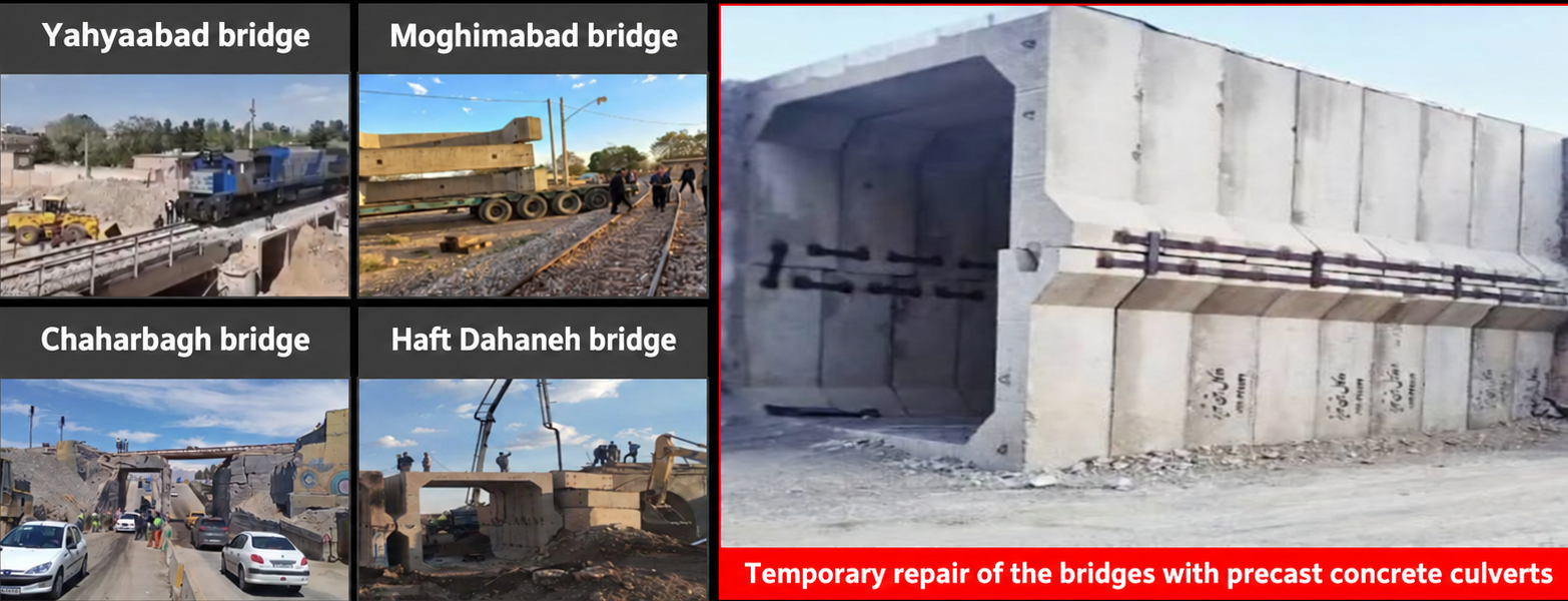
The pattern in what was hit is as telling as what was not. Unlike Iraq during the eight-year war of the 1980s, which went after the piers of the Qotur, Tele-Zang and Pol-e Siah bridges and put them out of use for years, the American and Israeli strikes chose smaller structures that could be repaired: Moghimabad, Yahyaabad, Chaharbagh and their like. Even B-1, the only large bridge struck, kept its piers. When Iraq destroyed the piers of the Qotur bridge in the 1980s, the repair took close to ten years. Almost every bridge struck this year was back in service within days, patched with prefabricated concrete culverts.
The damage was light but the strikes were a reminder of how exposed Iran's logistics are in the parts of the network that serve both military and civilian purposes, which is most of it.
Iran International's mapping shows that along the 25 principal roads that connect nearly every known missile production and assembly center and every "missile city" to one another, and that serve the bases of the Revolutionary Guards' and the regular army's ground forces, there are about 800 bridges and 90 large tunnels. On the national railway there are 670 bridges and 380 large tunnels, counting only structures with a deck longer than 30 meters.
Some of these points are strategic in the strict sense: damage to one would disrupt several routes at once. The west, north and southwest of the country are hard terrain because of the Zagros and Alborz mountains, but their dense road networks mean a strike there causes delay rather than severance. The southeast is another matter, and far more vulnerable.
The map sets out part of these findings.
Which rail bridges were struck
On April 7, before the ceasefire, six rail bridges were hit. None was large. But when four of them are placed on the national railway map, the point of the night becomes clear.
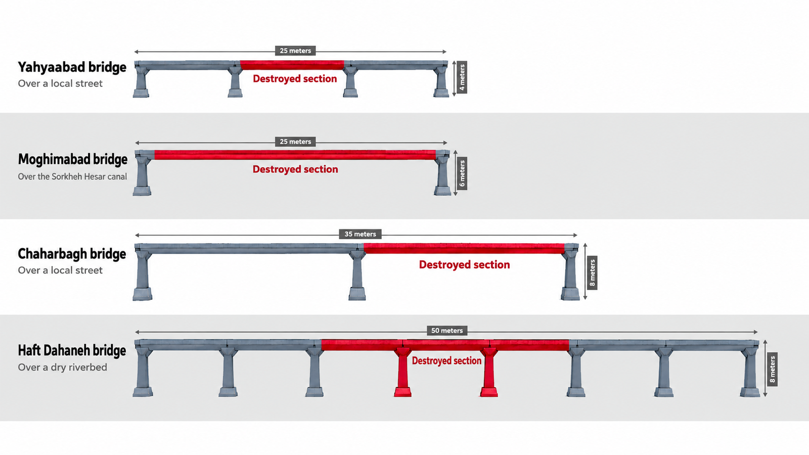
The strikes on the Moghimabad, Chaharbagh, Haft Dahaneh and Yahyaabad bridges severed Tehran from four directions of the country at once. The targets sat on the lines running east, west, north and south from the capital.
The four bridges are in Qom, Isfahan, Tehran and Alborz provinces, and on a map of Iran they look scattered. Set against the network as a whole, and excluding the two other bridges struck that night at Achachi and Aminabad in the northwest, they cut the capital off from the national system.
The bridges were reopened within days on prefabricated culverts. The night of April 7 remains a demonstration of how brittle the network's resilience is.
Their decks measure between 25 and 50 meters, their height between 4 and 8 meters, and they carry between two and seven spans. All are concrete.
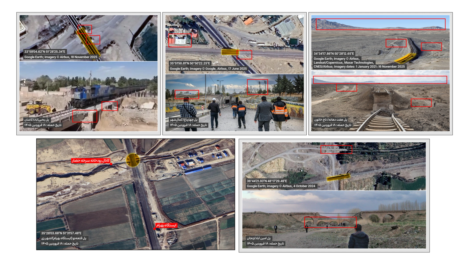
Iranian state media reported the rebuilding of three of the bridges within two to three days of the strikes. Two of the four crossed local roads and one a seasonal streambed. Only Moghimabad, which spans a local irrigation channel branching off the Sorkheh Hesar canal east of Tehran, took longer.
In every case except Chaharbagh, probably because of the heavy traffic on the road beneath it, prefabricated concrete culverts were used. The same culverts were used to repair the Aminabad bridge in Zanjan.
The propaganda of bridges "rebuilt in under 48 hours" was broadcast widely. The repairs are not permanent. On August 10, four months after the strikes, Jafar Mousavi, the mayor of Chaharbagh, said work on the Moghimabad bridge was continuing, and Jabbar Zakeri, head of the state railway company, said a new bridge with a more modern structure would have to be built there.
Rebuilding the bridges
Most of the bridges struck stood over dry or seasonal riverbeds, or over local streets. Ahmad Shahroodi, a senior forensic engineer at EFI Global in Ottawa and a federal construction dispute adjudicator in Canada whose work has included highway culverts and concrete structures, told Iran International that what lies beneath a bridge determines a great deal.
"The presence of a flowing river or a busy road under the bridge is one of the most important factors determining how long a rebuild takes," he said. "It also has a direct effect on the design and repair of the piers."
Prefabricated concrete culverts are standard practice in civil engineering, he said, provided the technical and safety requirements are met. But he added a caution: "The main concern in repairing damaged bridges is that newly installed culverts behave differently from the surviving sections. New and old parts are not the same in terms of expansion, contraction and structural behavior."
The foundations are the second problem. "The ground under the surviving sections has been compacted over years and has reached stability, while new surfaces have to be excavated and reinforced. If that is not done properly, there is a risk that the new sections settle after they come into service."
Without precise engineering data on the condition of the damaged structures, Shahroodi said, no firm judgment is possible. "In rebuilds carried out under time pressure there is always risk. Since the details of how these repairs were done are not available, one cannot judge definitively. But work done for show can potentially sacrifice quality for speed."
Strike on Aq Tekeh Khan
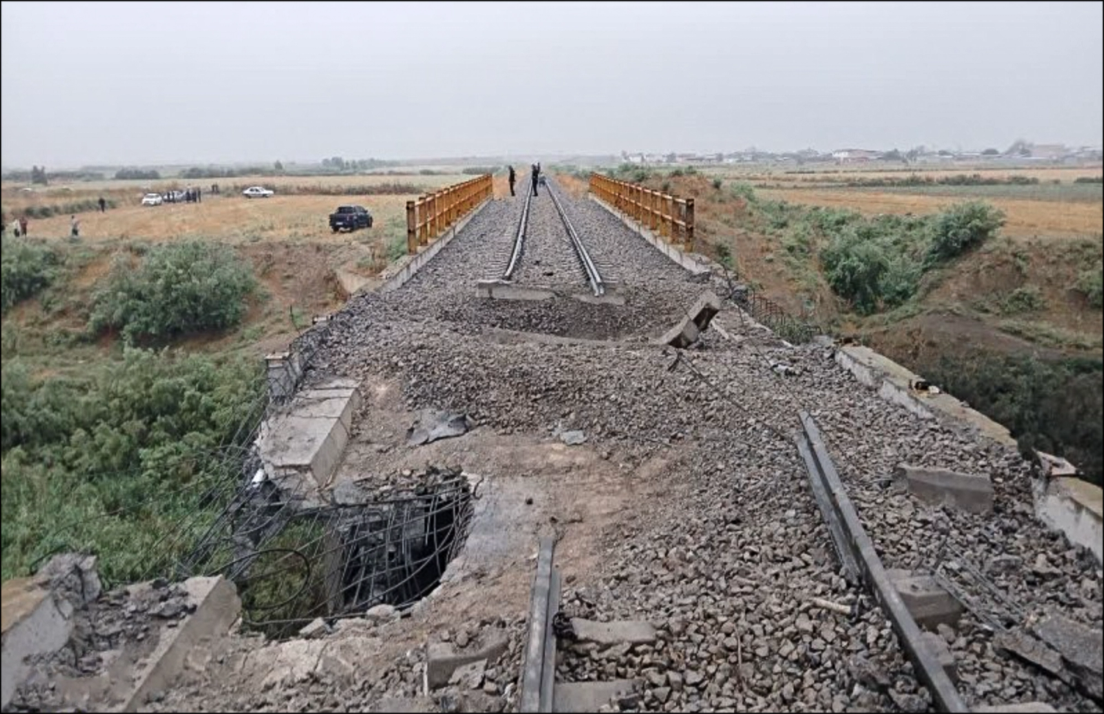
In the early hours of July 9, the United States struck a rail bridge called Aq Tekeh Khan, also known as Dogonchi, in Golestan province in Iran's northeast, near the Turkmen border. The attack was unlike the others in both its location and its weight. It was carried out with cruise missiles, and like the other bridge strikes it did limited damage.
The bridge lies on the line from the Incheh Borun border crossing to Gorgan, the provincial capital, a railway opened during Hassan Rouhani's presidency. It has played little part in Iran's rail trade, even since the naval blockade closed the country's ports.
Its significance is different: linked at Astrakhan to the Russian rail network and running through Kazakhstan and Turkmenistan, it connects Russia and Central Asia to warm-water ports through the Iranian system. There is no proof of a connection, but after the war began the number of unusual flights into Ashgabat airport in Turkmenistan rose markedly.
Missile program's access to the railway
The Islamic Republic's missile program is spread across dispersed research, production, assembly and storage sites throughout the country.
The strategic production and assembly complexes in and around Tehran include the Hakimieh complex, the Shahid Hemmat and Shahid Bakeri industrial groups at Parchin and Khojir east of the capital, and the Al-Ghadir complex at Bidganeh to its west. Propellant production sites at Garmsar and Shahroud, in Semnan province east of Tehran, connect to the capital by the eastern line and from there to the whole country.
In Isfahan, the Haftom-e Tir Industries of the Aerospace Industries Organization, the 15 Khordad missile group and the Ahmad Kazemi complex can reach the network through the main trans-Iranian line. The output of the assembly complexes can be distributed across the country over the same rails.
With the exception of the missile bases at Khorramabad, Khomein, Borazjan, Khormuj, Lar, Bastak, Bandar Kong and Khorgu, all of these sites lie beside the railway or a short distance from it.
Ground forces' access to the railway
The railway matters for the missile sites, but it matters just as much for moving the troops and equipment of the Revolutionary Guards' and the army's ground forces.
Of the 53 army bases, 59 Revolutionary Guards bases and eight ordnance depots inside Iran that Iran International has located, most sit on or near the network. For the depots in particular, the railway is doubly important.
Of the 112 ground-force bases of the Guards and the army, including infantry, commando, armored, mechanized and engineering brigades, 35 are not beside the network or are a long way from it. The other 77 are.
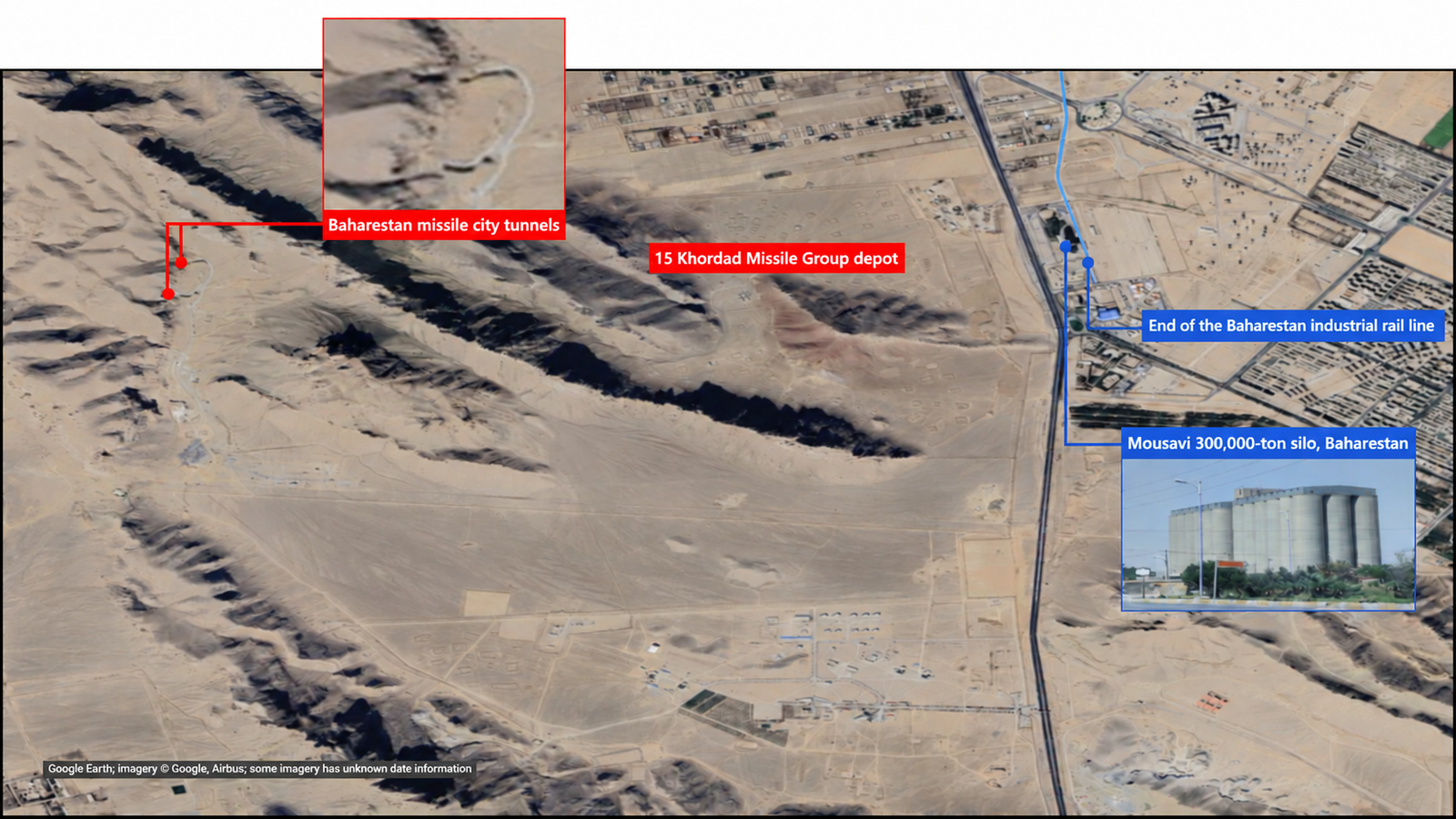
Like the roads, the railway serves two masters. Baharestan, in Isfahan province, is the illustration. The 300,000-tonne Mousavi grain silo there is one of the province's three large state silos and the biggest open silo in central Iran, and an industrial rail spur runs into it. A rail line into a wheat silo is unremarkable.
Directly opposite the silo, across Road 65, one of the highways examined in this report, sits the headquarters of the 15 Khordad missile group and its storage bunkers. Inside that compound, next to a base of the Guards' 14th Imam Hossein Division, the tunnels of the Baharestan missile base were dug in 2007.
Railway in industry, mining and energy
The railway is far more vulnerable than the road network, because it has no alternatives. In many of this year's strikes, particularly on bridges over dry riverbeds and seasonal streams, road crews quickly graded a dirt bypass through the riverbed. There is no equivalent for a rail line.
Rail carries another burden. Industrial railways are indispensable to Iran's mines and strategic industries. The Gol-Gohar iron ore mine and the Tabas coalfields, the Mobarakeh and Khuzestan steel works, and the petrochemical plants and refineries are all connected to the network.
Apart from the Lavan refinery and the petrochemical plants clustered around Asaluyeh and the South Pars gas field on the Persian Gulf coast, almost every major refinery and petrochemical complex in Iran is on the railway.
Railway in trade
Bandar Abbas and its Shahid Rajaee terminal, the country's largest container port, Bandar Imam Khomeini, the largest bulk port, and the smaller ports around them are all connected to the railway.
In the north, Amirabad, the largest Iranian port on the Caspian Sea and the route for roughly half of Iran's trade with Russia, is also on the network. Caspian shipping does not compare with the southern ports in volume or in the range of goods, but for trade with Russia it matters. In the two weeks from July 15 to July 27, 65 vessels docked at Amirabad, most of them Russian, and dry bulk made up most of the cargo.
Under the naval blockade, the trade that once flowed through busy ports such as Shahid Rajaee and Bandar Imam Khomeini has been forced onto roads and rails.
The China-Kazakhstan-Sarakhs land route is one of them. Pakistani traders send goods through the port of Gwadar to the Rimdan border crossing, a route that runs mostly by road and is discussed in the road section below.
The Razi crossing, in the northwest, does for Turkey what Sarakhs does for Central Asia: it connects by rail through Turkey to the Mediterranean port of Mersin. On August 14, Ali-Asghar Abdollahi, acting head of Razi customs, reported a 300 percent increase in rail trade through the crossing in the first four months of the Iranian year, from late March to late July, compared with the same period a year earlier. The Jolfa crossing into Azarbaijan was once significant and now matters little by comparison.
The railway also reaches the borders at Shamtigh with Afghanistan, Mirjaveh with Pakistan and Shalamcheh with Iraq.
Rail vulnerabilities in north and northwest
This region holds the Tehran-Mianeh, Qazvin-Rasht, Mianeh-Maragheh, Maragheh-Tabriz, Maragheh-Urmia, Tabriz-Jolfa and Sufian-Razi lines.
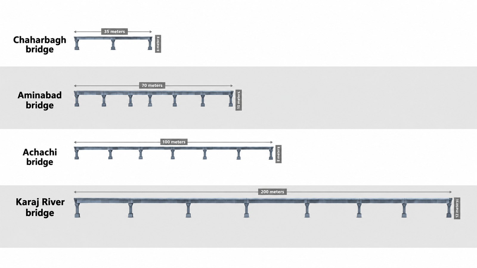
Every train in the region passes along the Tehran-Qazvin stretch. The Chaharbagh bridge struck in April is on it, and was quickly given a temporary repair. There are many small bridges like Chaharbagh on this stretch and only two large ones. For comparison, one of those two, over the Karaj river, has a 200-meter deck and stands close to 12 meters high.
Heading north, the Qazvin-Rasht line branches off toward the Caspian near Dowlatabad, and its bridges and tunnels begin after Nikuyeh and run to Rasht. There are 42 tunnels and 18 bridges on this stretch, and hundreds of culverts that were not counted.
The Qazvin-Rasht line is vulnerable in three places. Seven of its bridges have decks longer than 500 meters. In the northern section there are bridges a kilometer and a half long, built over fast-flowing rivers, particularly stretches of the Sefid Rud, where a damaged span would not be easy to repair.
From Qazvin to Mianeh there are 47 bridges and four tunnels. The Achachi and Aminabad bridges, near Mianeh and Zanjan, both struck in April, are on this stretch. Aminabad has six spans, a 70-meter deck and stands about 10 meters high; Achachi has six spans, a 100-meter deck and stands eight meters high.
About four kilometers from Achachi stands the historic Qaflankuh bridge, a 200-meter deck 20 meters above the Qezel Owzan river. Road 32 passes directly beneath it and then enters a tunnel. This stretch of Road 32, the transit route from Tehran to the northwestern borders, has no nearby alternative: if the rail bridge were damaged and the road temporarily blocked, the closest detour is 100 kilometers, by Road 26 and Freeway 2. The bridge is aged, and a replacement has been discussed repeatedly for 20 years without ever being built.
From Mianeh to Maragheh there are 33 bridges and 33 tunnels, most of them between Mianeh and Hashtrud. Twelve of the bridges are larger and more strategic than the rest. Among them, a 220-meter bridge between the Babak and Sheikh Safi stations is roughly comparable to Qaflankuh.
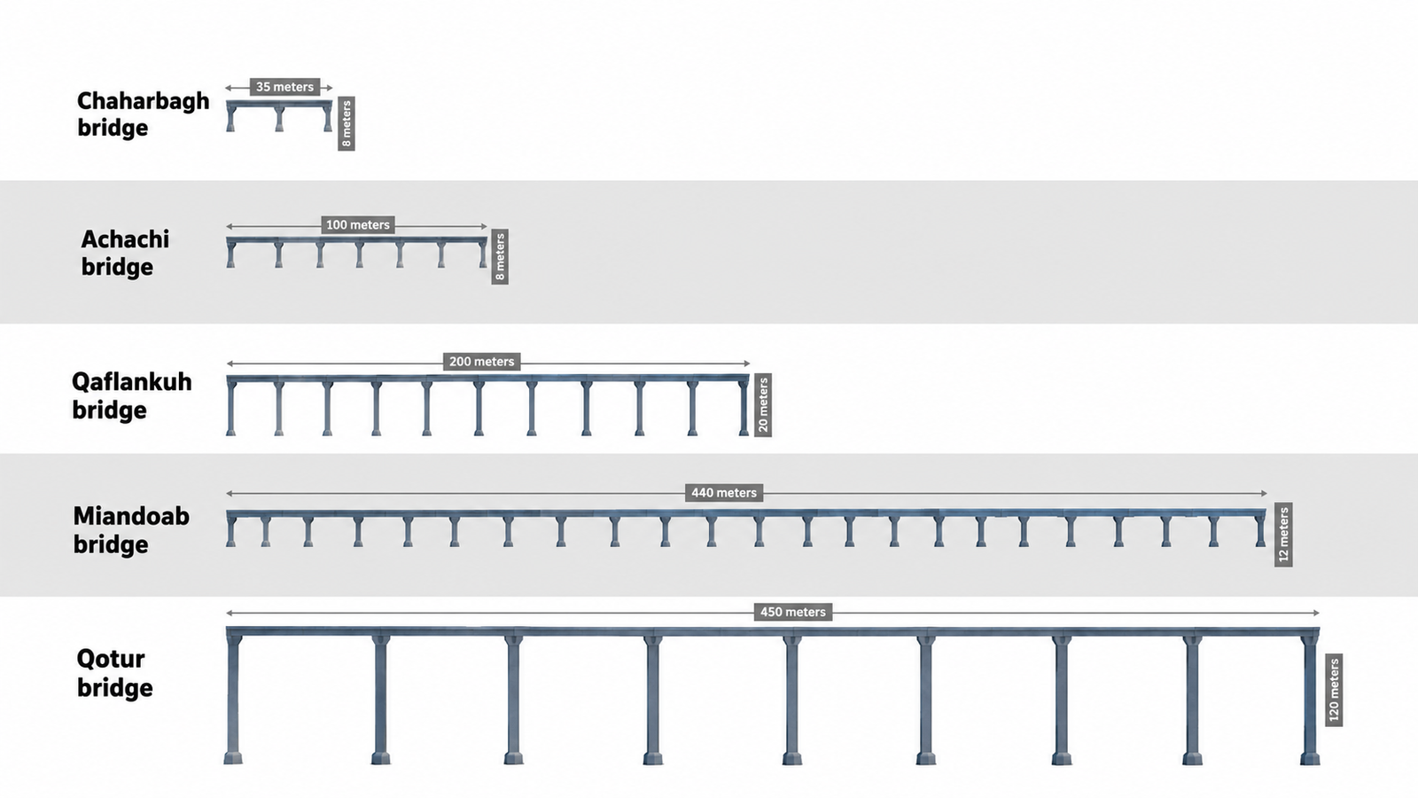
From Maragheh to Urmia there are 14 bridges with decks over 30 meters, seven of them larger than the others and six with decks over 100 meters. The most important is the 440-meter Miandoab bridge, 22 spans and about 12 meters high, over the Zarrineh Rud.
The line continues from Maragheh to Sufian, with 31 bridges over 30 meters and 33 tunnels. Between the Eghbali and Babakan stations in particular the terrain is difficult and the line crosses it on a succession of tunnels and bridges. In one stretch of about 500 meters between two tunnel mouths there are five bridges, the longest with a 100-meter span.
This region holds one of the clearest historical examples of a strike meant to do lasting damage to a transport link. During the eight-year war, Iraq attacked the Qotur bridge on this line several times. Unlike the American and Israeli strikes, those attacks damaged the piers. Reconstruction began in 1985 and was completed in 1995.
Rail vulnerabilities in center and southwest
From Parandak, southwest of Tehran, the trans-Iranian railway runs west on two lines: one to Hamedan and on toward Sanandaj, the other from Qom through Arak, Shazand, Malayer and Bisotun to the outskirts of Kermanshah.
The southwestern railway begins at the Shalamcheh crossing into Iraq and at Khorramshahr, in the far southwest, and reaches Ahvaz, where it meets the line from Bandar Imam Khomeini and Bandar Mahshahr. From Ahvaz it runs through Shush and Dezful to Shazand, joins the Qom-Kermanshah line, and so reaches Tehran.
Another line runs southeast from Qom through Kashan to the junction at Badrud, where it splits toward Ardakan and toward Isfahan. At Isfahan it splits again, toward Ardakan and toward Shiraz.
The strike on the Haft Dahaneh bridge in Qom severed the connection to Kermanshah, Arak, Shazand, Ahvaz, Bandar Mahshahr, Bandar Imam Khomeini and Khorramshahr. The strike on Yahyaabad severed the line to Isfahan, Ardakan and Shiraz, and with it much of the south, center and southeast.
Rail bridges and tunnels in the center and southwest
From Bandar Mahshahr to Ahvaz, from Khorramshahr to Ahvaz and from Ahvaz to Qom there are 113 tunnels and 74 bridges with spans over 30 meters in total.
They are densest in two sections: from Bandar Mahshahr and Khorramshahr to Haft Tappeh, and from Dezful to Dorud. The terrain there is difficult, and some of the bridges and tunnels are exceptional in length and height for the whole national network. The only comparable stretch of the Zagros crossing is the Veresk section of the northern line, where the Trans-Iranian Railway of the 1930s climbs the Alborz on the spirals Iranians call the Three Golden Lines.
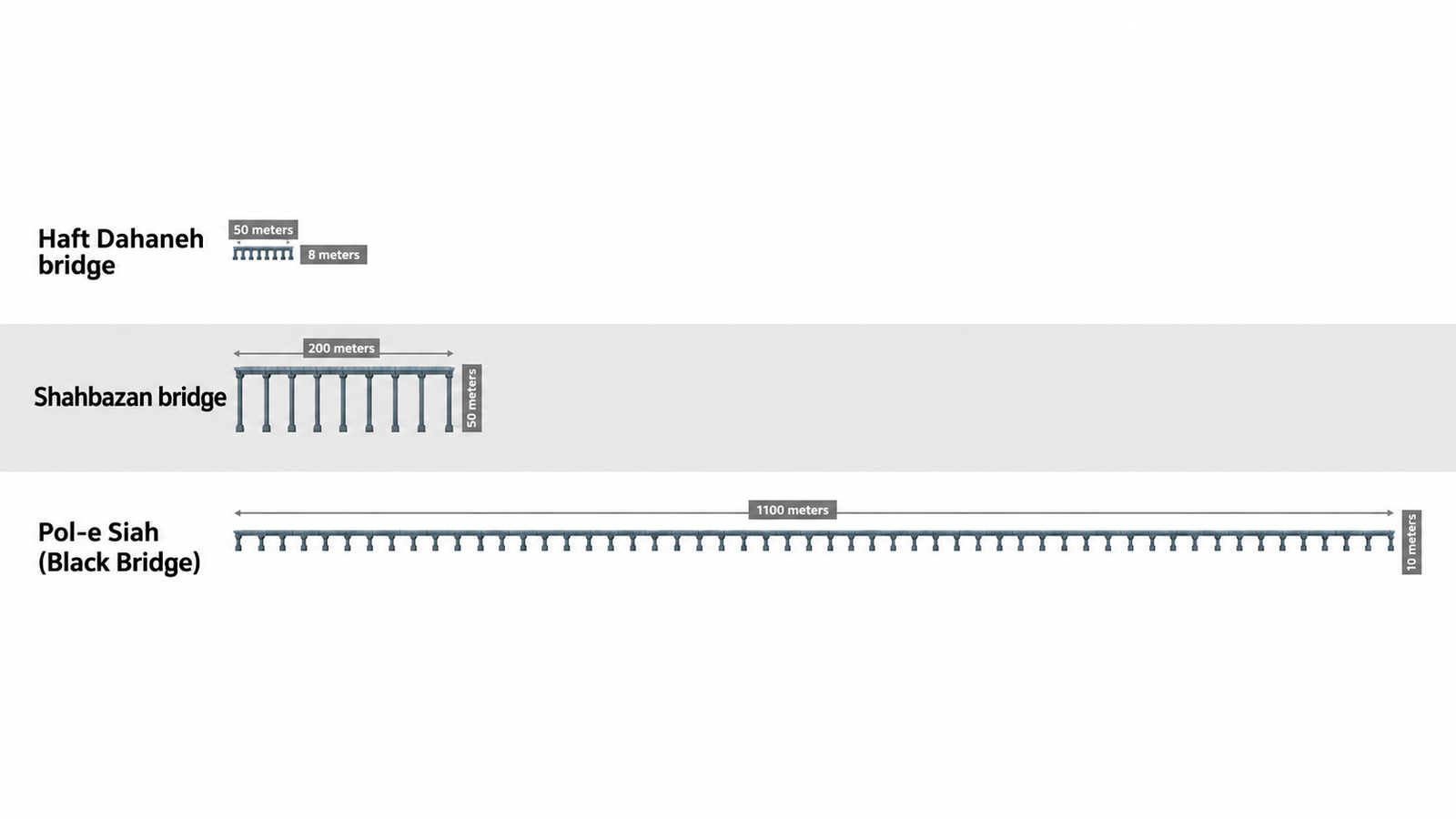
The best-known bridge on this route is the Pol-e Siah, the Black Bridge at Ahvaz, which carries the line more than a kilometer across the Karun river. In parts of the southern section the railway crosses the Hoor al-Azim marshes.
Of the 74 bridges, 24 are longer than 100 meters. Apart from the Black Bridge, they cross the Dez, Sezar and Bakhtiari rivers and a series of seasonal streams and gorges. Some matter more than others, and if damaged would not be easily rebuilt.
Rail vulnerabilities in the center
The Badrud-Qom line is strategic. It connects Shiraz, Isfahan, Kerman and Yazd in the center, Bandar Abbas in the south and Zahedan in the southeast to Tehran. Yahyaabad, on the edge of Kashan, was one of three grade-separated crossings of its kind on this stretch. Apart from one bridge near Mehrabad and one near Badrud, the other structures are small culverts.
From Badrud to Isfahan, and on the branches south of Isfahan toward Mobarakeh, Baharestan and the Zob Ahan steelworks, there are 60 bridges over 30 meters and two tunnels. Only two bridges exceed 100 meters, which makes this a relatively secure stretch.
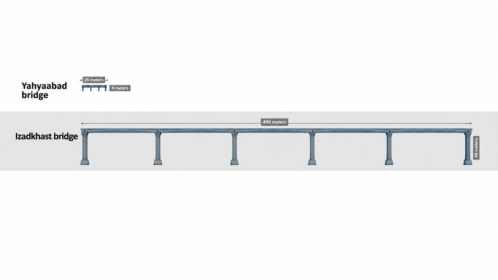
From Isfahan to Shiraz, however, there are 23 bridges and 21 tunnels, six of the bridges large, among them those at Izadkhast and Marvdasht.
From Ardakan, two lines run west: a northern one to Tehran by way of Badrud and a southern one to Isfahan. The northern line has 11 bridges and the southern eight, with dozens of small culverts, all over seasonal streams and crossings. There is no large or strategic bridge in this area.
Rail vulnerabilities in the south and southeast
From Bandar Abbas and Shahid Rajaee to Bafgh there are 118 bridges and 21 large tunnels. Before the blockade, this line was of exceptional importance because of the traffic through Shahid Rajaee and the ports around it.
Thirty-four of its bridges are larger than the rest. The stretch has tunnels of up to three kilometers and bridges that are long or high, including those near Emergency Station 6, near Hajiabad, one close to the Gol-Gohar mine and those around Abdun Anjir.
In the southeast, from Mirjaveh on the Pakistani border to Bafgh, there are 15 tunnels and 68 bridges over 30 meters. Fourteen bridges in the Kalat station area are longer and higher than the rest, among them those near Kalapadeh and the Tehrud and Mehrdad stations. Hundreds of culverts and small bridges line this route.
Rail vulnerabilities in the northeast and north
In the northeast and north, one line runs east to west from Sarakhs on the Turkmen border to Garmsar, and one runs north to south from Incheh Borun to Garmsar. Further south, a third line runs from Shamtigh on the Afghan border to Ardakan and on toward Fars, between the Lut and Dasht-e Kavir deserts. The Shamtigh-Ardakan and Sarakhs-Garmsar lines are joined by a link from Dizbad station to Torbat Heydarieh. The Chadormalu iron mine and the Tabas coalfields on the southern edge of this region depend on the railway.
The strike on the Moghimabad bridge, also known as Qaleh Now, cut this whole section off from Tehran.
From Sarakhs to Tehran there are 26 large bridges and three tunnels, plus dozens of small culverts. The tunnels are all in the east. The bridges are concentrated in two stretches, Sarakhs to Dizbad and Jajarm station to Damghan; between Dizbad and Jajarm there is no bridge of consequence. The eight-span Sorkheh bridge, about 100 meters long, is comparable to Haft Dahaneh in Qom.
The northern line plus the Incheh Borun-Garmsar line have 58 bridges and 76 tunnels between them, with hundreds of unlocated culverts. From Incheh Borun to Pas Shahi, the junction at Qaem Shahr, there are five large bridges, one of them Aq Tekeh Khan. The bridges and tunnels cluster around Shirgah, between Emaratsar and Shurab, and between Simin Dasht and Bonkuh. The Veresk section and the Sorkhabad lines, the celebrated engineering of the Trans-Iranian Railway, are on this line.
Road network
Seen alongside the military sites and missile bases, these are the country's most important roads. Nearly every missile base, whether the storage complexes known as missile cities or the production and assembly centers, sits beside them.
Like the railway, the roads cannot help serving two purposes. They connect the major cities to one another and to the ports and customs posts. Some, such as Roads 95, 22, 2 and 44, are transit routes and form parts of the AH75, AH70 and AH1 corridors of the Asian Highway network.
Fourteen north-south roads and highways and 11 east-west routes link the center of the country to the ground-force bases of the Guards and the army inside Iran. Roads 5, 7, 37, 49, 65, 67, 71, 73, 77, 79, 83, 91, 93 and 95 run north to south; Roads 2, 22, 32, 44, 46, 48, 64, 84, 94, 96 and 98 run east to west.
Roads that connect missile bases and military sites
Apart from the missile bases at Khomein and Urmia, every known missile base and missile industrial site inside Iran is reachable through this road network.
There are numerous secondary alternatives. But the record of this year's bridge strikes, set out below, shows that blocking main routes and their alternatives is not impossible.
The routes look most vulnerable in the southeast. The region has two features: ground-force bases are far fewer than in the west or northeast, and the roads offer little variety, while natural barriers, particularly the Barez and Taftan mountain ranges, constrain them.
In several of this year's strikes, road crews graded the dry riverbed beneath a damaged bridge into a bypass. In the southeast, once the rains begin, that is not possible on the region's many seasonal rivers and the bridges that cross them.
Which road bridges were struck
The strikes on road bridges, like those on rail, were reported piecemeal. Seen against the routes and the sensitive sites they serve, the targets were chosen with purpose.
Eight road bridges were struck in all, in East Azarbaijan, Alborz and Hormozgan provinces: four before the ceasefire and four after it.
On April 2, the United States struck the B-1 bridge twice. It was the largest bridge hit in the entire campaign against roads and rail. Its piers were not targeted.
On April 3, two bridges on Road 32 in East Azarbaijan were hit, and on April 7 another on Freeway 2, also in East Azarbaijan.
On July 17, after the ceasefire, the United States struck four bridges in Hormozgan province, in what became known as the Bandar Khamir strikes.
The B-1 bridge
The first bridge attack of the war was on B-1, on the northern ring road of Karaj, west of Tehran, which was still under construction. The piers were undamaged; imagery shows the deck destroyed across three spans. It is one of the few cases of serious structural damage to a bridge. The cost of rebuilding it has been estimated at 25 to 37 trillion rials, roughly $11 million to $16 million at market rates, and the time at about a year.
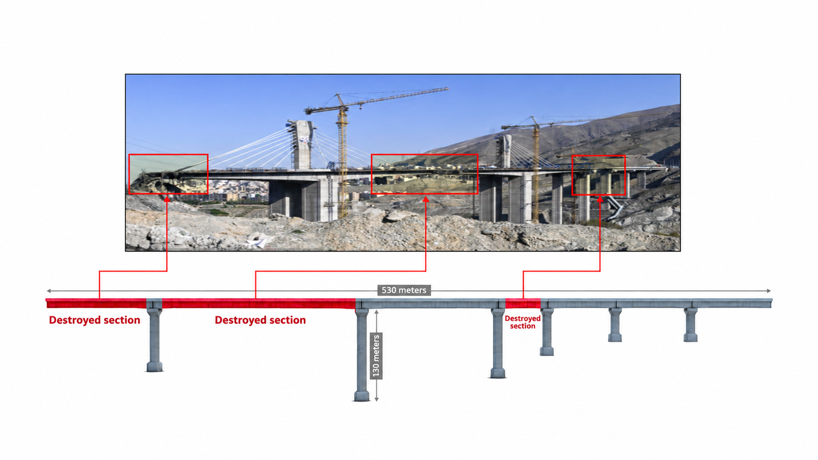
Two main routes connect Tehran and the east of the country to the west through this area: Road 32, which passes through the city of Karaj, and Freeway 2, which runs along its southern ring road. Both are chokepoints for the north, northwest and west, and both are usually congested.
The northern ring road, on which B-1 stands, was begun in recent years and had not fully opened when it was struck. It is a lightly used route north of the city. To the east it meets the Shohada-ye Alborz expressway, the continuation of Tehran's Hemmat expressway, on whose northern side sit the two missile complexes at Garmdarreh.
To the west, beside the village of Chenarak, is the headquarters of the Guards' 10th Seyyed al-Shohada Division. The ring road allows traffic from west Tehran to reach Freeway 2 directly.
East Azarbaijan bridges
All three strikes on road bridges in East Azarbaijan fell between Rajaein in Zanjan and Bostanabad, on Road 32 and Freeway 2. The two roads run parallel for long stretches and cross each other at many interchanges.
A 60-meter bridge attached to the 150-meter Qareh Tappeh tunnel and the 100-meter Mazmin bridge, both on Road 32, were struck and have been rebuilt along with the tunnel. The 160-meter Hashtrud (Bayat) bridge on Freeway 2 had not been fully repaired by mid-September, five months after it was hit.
The purpose of these strikes is unclear. With Road 24 near Hashtrud and Road 26 near Mianeh as alternatives, plus rural roads, they did not close the east-west route. They lengthened it by 40 to 50 kilometers.
Unlike the southeast, the density of settlements in the northwest means that outside a few specific corridors linking two provinces, cutting one region from another is not possible even by striking more than ten bridges. What these strikes achieve is distance.
The bridges here, though, have a particular feature: there are few dry seasonal riverbeds. They span permanent rivers and relatively deep valleys, which makes both rebuilding and bypassing harder.
Bandar Khamir bridges
The strikes in Hormozgan after the ceasefire became known as the Bandar Khamir strikes, and unlike the East Azarbaijan case they did cut the east-west route.
Two main roads run through the area, Roads 96 and 94. The Nimeh Kareh, Kahurestan and Gariveh bridges were on the main routes. With those damaged, traffic could have used the Gachin road as an alternative, but a bridge on that road was struck as well.
The result was that the road from west to east along the coast was closed, though dirt bypasses were built through the dry riverbeds.
On the map, the Gachin, Gariveh and Kahurestan bridges are located from published images of their destruction or repair. No clear image of the Nimeh Kareh bridge has been published. Near the village of that name are culverts with decks shorter than 20 meters; the only sizable bridge in the area is the four-span structure marked on the map.
Road bridges and tunnels
Along the 25 key roads Iran International examined there are close to 900 bridges with decks over 30 meters and tunnels. There are 146 strategic points on the road network and 175 on the railway that have not been struck.
They are considerably more strategic than the bridges hit in East Azarbaijan and at Bandar Khamir. Some are junctions with other highways or with the railway, where damage would cut more than one route.
They lie in the north, west and south within or along the Alborz and Zagros ranges, in the center along ranges such as the Shotori mountains, and in the southeast beside the Barez and Taftan mountains.
Ground forces' access to the roads
Unlike the railway, the roads have many alternatives, with a few exceptions. The strike on the Achachi rail bridge disrupted transport; in the same area, the strikes on the Qareh Tappeh, Mazmin and Hashtrud bridges and tunnel on Road 32 and Freeway 2 lengthened the journey but, thanks to Roads 26 and 24, did not close the route, unlike Bandar Khamir.
Almost every missile production, assembly and storage site, and every ground-force base of the Guards and the army, can be reached through about 30 roads in the country.
Except in the southeast, the south and to some extent the southwest and northeast, cutting a region off by striking a few bridges or tunnels is not possible. In the northwest, damage to bridges and tunnels produces alternatives of widely varying length and quality.
Ground-force bases struck so far
In both the 12-day war and this year's war, the targets were not only missile cities, provincial Guards commands and the intelligence and security apparatus. Barracks of infantry and armored brigades, and ordnance depots, were on the list.
On April 2, the 61 Moharram artillery base at Torbat Heydarieh was struck. The Bostanabad barracks, headquarters of the Guards' Ashura Corps, was hit twice in the 12-day war. Bases of brigades under the army's 16th Armored Division in Qazvin, including the Mokhaberi barracks in Zanjan, were struck in the 12-day war and again this year.
The Ranjbar barracks, headquarters of the 92nd Armored Division in Ahvaz, was attacked several times. The army's 164th Infantry Brigade at Piranshahr was hit in the 12-day war. The Habibollahi barracks and depot in Ahvaz were among this year's targets.
The strikes continued after the ceasefire. The most prominent was a heavy attack on July 15 on the base of the army's 388th Infantry Brigade at Bampur, in Sistan and Baluchestan.
Many military sites serve several purposes. Some are both troop garrisons and ammunition stores. Some adjoin the missile bases known as missile cities: the missile tunnels at Qom inside the Manzariyeh depot, for instance, and the Baharestan tunnels beside the Imam Hossein Division base.
A large number of regional Guards barracks and headquarters were also struck in both wars and are not mapped here, among them the Deylaman barracks in Shahr-e Rey, the Sarallah headquarters and the Imam Hasan barracks in Karaj.
Vulnerability that remains
The record of strikes on rail and road bridges in this year's war and the months since the ceasefire points to a method. The targeting of transport infrastructure was built not on broad, lasting destruction but on temporary, precise disruption at chokepoints.
Choosing smaller, repairable bridges and sparing the piers of the large ones allowed Iran to rebuild quickly with prefabricated culverts. It also exposed how fragile a logistics network is when its military and civilian functions run on the same rails and the same roads.
Along the 25 strategic roads and the national railway, hundreds of sensitive points remain, where a single strike would disrupt several vital routes at once. The west and northwest have a measure of resilience because alternatives are dense. The southeast does not.
The year's strikes have made one thing plain. Iran's transport networks are not simply civilian infrastructure. They are an integral part of the Islamic Republic's military logistics inside its own borders, and no number of temporary repairs conceals it.

No comments:
Post a Comment
Note: Only a member of this blog may post a comment.